Cayman Islands
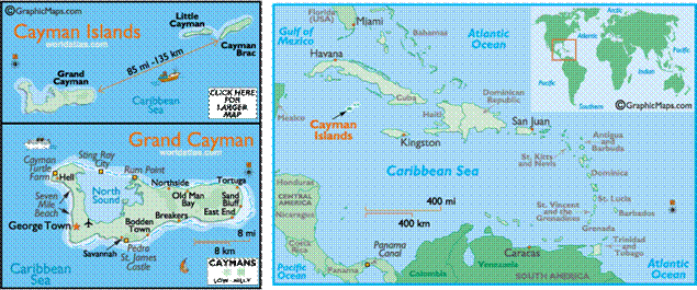
The Cayman Islands are a British
overseas territory located in the western Caribbean Sea.
The territory comprises the islands of Grand Cayman, Cayman Brac,
and Little Cayman, located south of Cuba
and northwest of Jamaica.
The territory is a major offshore financial centre in the Caribbean.
The Cayman Islands were sighted
by Christopher Columbus, on 10 May 1503 on his fourth and final voyage to the New World. The first recorded English visitor to the
islands landed there in 1586 and named them the Cayman
Islands after caiman, the Neo-Taino
nation term for alligator.
The islands, along with nearby Jamaica,
were captured by, then ceded to England in 1670 under the Treaty of
Madrid. They were governed as a single colony with Jamaica
until 1962 when they became a separate British
Overseas Territory
and Jamaica
became an independent Commonwealth realm.
The island
of Grand Cayman, which
lies largely unprotected at sea level, was hit by Hurricane Ivan on 11 and 12
September 2004, which destroyed many buildings and damaged 90% of them. Power,
water and communications were all disrupted in some areas for months as Ivan
was the worst hurricane to hit the islands in 86 years. However, Grand Cayman forced a major rebuilding process and within
two years its infrastructure was nearly returned to pre-Ivan levels. The Cayman Islands have the dubious honor of having
experienced the most hurricane strikes in history. Due to the proximity of the
islands, more hurricane and tropical systems have affected the Cayman Islands
than any other region in the Atlantic basin (brushed or hit every 2.23 years).
The Cayman Islands enjoy a high global
standard of living fully dependent upon tourism and banking.